
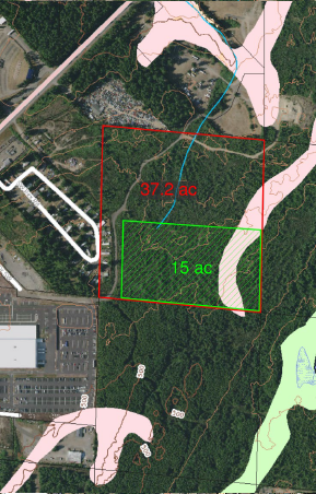
Site B
Bree Drive SW, Bremerton, WA 98312 (north site)
Functional Screening summary
- Functional Scoring Rank: tied for #6
- Accessibility: moderate improvements needed
- Adjacencies: minimal impact
- Developability: straightforward development
- Infiltrative soils: can infiltrate storm system following Industrial Stormwater General Permit requirements
- Fuel consumption from base: less than 5% charging loss
- Site configuration: easily accommodates program
- Environmental justice impacts: 10-20% of census tract
- Utility availability: storm and sewer utility service lines greater than 0.25 mile; fiber, gas, cable television and telephone between 500 feet and 0.25 mile; electric less than 500 feet to service line
- 2nd Tier Critical Area Setbacks/Mitigation: no Critical Area mitigation
- 2nd Tier Displacement: no displacements
Comparative Analysis findings
TIME FACTORS
- Acquisition – Single large parcel with one owner; option to purchase sub-parcel of reduced size.
- Land Use – Undeveloped. Expect acceptable land use. Note: subarea zoning marked as “general industrial (GI)”.
- Permitting – May require environmental permit for on-site stream.
- Construction – Standard forest practices permit.
FUNCTIONALITY
- Access – Requires travel along State Route 3 to reach Charleston Base (6.7 miles). Time in minutes: 10-15
- Maintenance/Replacement – Standard maintenance.
- Flexibility – Room for expansion.
- Septic/Sewer – Septic.
DEVELOPABILITY
- Site Prep – Light timber harvesting.
- Grading/Drainage/Utilities – Easy grading; infiltrative soils; limited access to utilities.
- Access – Straight/flat access and single right-of-way from Bree Dr.
- Risk – Straightforward construction.
- Community – Minimal impact due to remote nature of the site.
COST
- Administrative Cost = 10%
- Assessed Value = $605,000 for 15.0 acres, $1,498,000 for full 37.2 acres
- Design/Permitting Costs = 12%
- Development Costs = TBD
ENVIRONMENTAL
- Possible water course present. Requires critical area site assessment.